
2026 edition
![]() This map highlights the Southern Scenic Route from Dunedin to Milford Sound and Queenstown. We have also included a Driving Times and Distance Chart.
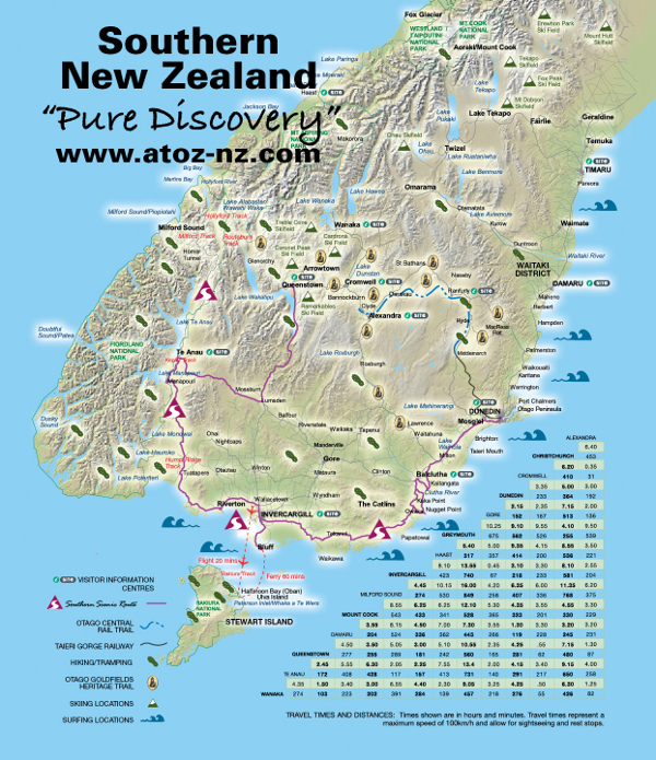
This map highlights the Southern Scenic Route from Dunedin to Milford Sound and Queenstown. We have also included a Driving Times and Distance Chart.
 |
| Alexandra | |||||||||||||
|
453 6.40 |
Christchurch | ||||||||||||
|
31 0.35 |
410 6.20 |
Cromwell | |||||||||||
|
192 3.00 |
364 5.00 |
223 3.35 |
Dunedin | ||||||||||
|
136 2.00 |
513 7.15 |
167 2.35 |
152 2.15 |
Gore | |||||||||
|
539 9.50 |
255 4.10 |
526 9.55 |
562 9.10 |
675 10.25 |
Greymouth | ||||||||
|
221 3.50 |
536 8.55 |
200 4.15 |
414 9.35 |
357 5.00 |
317 5.40 |
Haast | |||||||
|
204 2.55 |
581 8.10 |
233 3.30 |
218 3.10 |
67 0.45 |
740 13.55 |
423 8.10 |
Invercargill | ||||||
|
375 6.20 |
768 11.35 |
336 6.00 |
407 6.35 |
258 4.20 |
849 16.00 |
530 10.15 |
274 4.45 |
Milford Sound | |||||
|
229 3.30 |
330 4.55 |
201 3.55 |
323 4.35 |
365 5.30 |
528 12.10 |
341 6.25 |
433 6.25 |
543 8.55 |
Mount Cook | ||||
|
231 3.20 |
245 3.20 |
228 3.30 |
119 1.30 |
266 3.55 |
443 7.30 |
362 7.00 |
336 4.50 |
524 8.15 |
204 3.55 |
Oamaru | |||
|
87 1.30 |
480 7.15 |
62 0.55 |
281 4.25 |
165 2.35 |
560 10.55 |
242 5.10 |
181 3.00 |
289 5.05 |
255 3.50 |
277 4.50 |
Queenstown | ||
|
258 4.00 |
650 9.15 |
217 3.40 |
291 4.15 |
140 2.00 |
731 13.40 |
413 7.55 |
157 2.25 |
117 2.05 |
428 6.30 |
408 5.55 |
172 2.45 |
Te Anau | |
|
82 1.25 |
426 6.30 |
55 0.50 |
276 4.25 |
218 3.25 |
457 9.05 |
139 2.30 |
284 4.40 |
391 6.55 |
202 3.00 |
223 3.40 |
103 1.50 |
274 4.35 |
Wanaka |
Distances are in Kilometres and times in Hours and Minutes.
| This Site © A To Z Publications Ltd, New Zealand, 1997 - 2026. Enquiries to info@atoz-nz.com |